Category:Démolition de la tour 12 rue Renoir (Offemont)
Jump to navigation
Jump to search
| Object location | | View all coordinates using: OpenStreetMap |
|---|
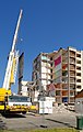
Français : Démolition d'une tour, 12 rue Renoir, à Offemont.
Pages in category "Démolition de la tour 12 rue Renoir (Offemont)"
The following 3 pages are in this category, out of 3 total.
Media in category "Démolition de la tour 12 rue Renoir (Offemont)"
The following 126 files are in this category, out of 126 total.
-
 2019-06-25 09-11-12 demolition-tour-Offemont.jpg 3,191 × 4,611; 8.01 MB
-
 2019-06-25 09-12-51 demolition-tour-Offemont.jpg 1,981 × 2,894; 3.42 MB
-
 2019-06-25 09-12-55 demolition-tour-Offemont.jpg 1,073 × 2,337; 1.52 MB
-
 2019-06-25 09-12-56 demolition-tour-Offemont.jpg 1,351 × 2,556; 2.09 MB
-
 2019-06-25 09-15-33 demolition-tour-Offemont.jpg 6,000 × 4,000; 9.18 MB
-
 2019-06-25 09-19-25 demolition-tour-Offemont.jpg 6,000 × 4,000; 11.14 MB
-
 2019-06-25 09-22-15 demolition-tour-Offemont.jpg 4,000 × 6,000; 10.3 MB
-
 2019-06-25 09-24-08 demolition-tour-Offemont.jpg 6,000 × 4,000; 11.2 MB
-
 2019-06-25 09-27-33 demolition-tour-Offemont.jpg 2,816 × 1,901; 2.96 MB
-
 2019-06-25 09-57-42 demolition-tour-Offemont.jpg 4,000 × 6,000; 9.92 MB
-
 2019-06-25 09-58-12 demolition-tour-Offemont.jpg 4,000 × 6,000; 6.23 MB
-
 2019-06-25 09-58-37 demolition-tour-Offemont.jpg 4,000 × 2,667; 3.24 MB
-
 2019-06-25 09-59-46 demolition-tour-Offemont.jpg 4,000 × 2,667; 3.23 MB
-
 2019-06-25 09-59-50 demolition-tour-Offemont.jpg 4,000 × 6,000; 8.08 MB
-
 2019-06-25 10-05-23 demolition-tour-Offemont.jpg 4,000 × 6,000; 7.16 MB
-
 2019-06-25 10-05-49 demolition-tour-Offemont.jpg 4,000 × 6,000; 7 MB
-
 2019-06-25 10-05-56 demolition-tour-Offemont.jpg 4,000 × 6,000; 8.81 MB
-
 2019-06-25 10-06-41 demolition-tour-Offemont.jpg 4,000 × 2,667; 5.74 MB
-
 2019-06-25 10-34-00 demolition-tour-Offemont.jpg 4,000 × 2,667; 6.81 MB
-
 2019-06-25 10-34-03 demolition-tour-Offemont 02.jpg 4,000 × 2,667; 8.09 MB
-
 2019-06-25 10-34-03 demolition-tour-Offemont.jpg 4,000 × 2,667; 8.12 MB
-
 2019-06-25 10-34-14 demolition-tour-Offemont 02.jpg 6,000 × 4,000; 16.08 MB
-
 2019-06-25 10-34-14 demolition-tour-Offemont.jpg 4,000 × 2,667; 8.32 MB
-
 2019-06-25 10-37-08 demolition-tour-Offemont.jpg 4,000 × 2,667; 3.66 MB
-
 2019-06-25 10-37-32 demolition-tour-Offemont.jpg 4,000 × 2,667; 3.54 MB
-
 2019-06-25 10-38-55 demolition-tour-Offemont.jpg 4,000 × 2,667; 3.43 MB
-
 2019-06-25 10-39-27 demolition-tour-Offemont.jpg 4,000 × 2,667; 3.72 MB
-
 2019-06-25 10-39-43 demolition-tour-Offemont.jpg 4,000 × 2,667; 3.64 MB
-
 2019-06-25 10-39-46 demolition-tour-Offemont.jpg 4,000 × 2,667; 3.72 MB
-
 2019-06-25 10-41-50 demolition-tour-Offemont.jpg 4,000 × 2,667; 3.81 MB
-
 2019-06-25 10-41-53 demolition-tour-Offemont.jpg 4,000 × 2,667; 3.72 MB
-
 2019-06-25 10-42-50 demolition-tour-Offemont.jpg 4,000 × 2,667; 3.34 MB
-
 2019-06-25 10-43-24 demolition-tour-Offemont.jpg 4,000 × 2,667; 3.44 MB
-
 2019-06-25 10-45-42 demolition-tour-Offemont.jpg 4,000 × 2,667; 3.99 MB
-
 2019-06-25 10-48-11 demolition-tour-Offemont.jpg 4,000 × 2,667; 4.38 MB
-
 2019-06-25 10-50-10 demolition-tour-Offemont.jpg 4,000 × 2,667; 4.38 MB
-
 2019-06-25 10-50-45 demolition-tour-Offemont.jpg 4,000 × 2,667; 4.42 MB
-
 2019-06-25 10-50-54 demolition-tour-Offemont.jpg 4,000 × 2,667; 3.69 MB
-
 2019-06-25 10-51-10 demolition-tour-Offemont.jpg 4,000 × 2,667; 3.75 MB
-
 2019-06-25 10-51-22 demolition-tour-Offemont.jpg 4,000 × 2,667; 3.79 MB
-
 2019-06-25 10-52-43 demolition-tour-Offemont.jpg 4,000 × 2,667; 4.07 MB
-
 2019-06-25 10-53-40 demolition-tour-Offemont.jpg 4,000 × 2,667; 3.94 MB
-
 2019-06-25 14-28-32 demolition-tour-Offemont.jpg 4,000 × 2,667; 3.57 MB
-
 2019-06-25 14-28-50 demolition-tour-Offemont.jpg 4,000 × 2,667; 4.09 MB
-
 2019-06-25 14-48-47 demolition-tour-Offemont 02.jpg 4,000 × 6,000; 7.57 MB
-
 2019-06-25 14-48-47 demolition-tour-Offemont.jpg 4,000 × 6,000; 7.56 MB
-
 2019-06-25 14-49-33 demolition-tour-Offemont.jpg 4,000 × 6,000; 7.46 MB
-
 2019-06-25 14-52-47 demolition-tour-Offemont.jpg 4,000 × 2,667; 3.86 MB
-
 2019-06-25 14-53-20 demolition-tour-Offemont.jpg 4,000 × 2,667; 4 MB
-
 2019-06-25 15-12-25 demolition-tour-Offemont.jpg 4,000 × 2,667; 5.73 MB
-
 2019-06-25 15-16-05 demolition-tour-Offemont 02.jpg 4,000 × 2,667; 3.99 MB
-
 2019-06-25 15-16-05 demolition-tour-Offemont 03.jpg 4,000 × 2,667; 3.94 MB
-
 2019-06-25 15-16-05 demolition-tour-Offemont 04.jpg 4,000 × 2,667; 3.95 MB
-
 2019-06-25 15-16-05 demolition-tour-Offemont.jpg 4,000 × 2,667; 3.95 MB
-
 2019-06-25 15-16-06 demolition-tour-Offemont 02.jpg 4,000 × 2,667; 3.89 MB
-
 2019-06-25 15-16-06 demolition-tour-Offemont 03.jpg 4,000 × 2,667; 4.3 MB
-
 2019-06-25 15-16-06 demolition-tour-Offemont 04.jpg 4,000 × 2,667; 4.26 MB
-
 2019-06-25 15-16-06 demolition-tour-Offemont 05.jpg 4,000 × 2,667; 4.26 MB
-
 2019-06-25 15-16-06 demolition-tour-Offemont.jpg 4,000 × 2,667; 3.92 MB
-
 2019-06-25 15-16-07 demolition-tour-Offemont 02.jpg 4,000 × 2,667; 4.3 MB
-
 2019-06-25 15-16-07 demolition-tour-Offemont.jpg 4,000 × 2,667; 4.4 MB
-
 2019-06-25 15-16-13 demolition-tour-Offemont.jpg 4,000 × 2,667; 4.34 MB
-
 2019-06-25 15-40-36 demolition-tour-Offemont.jpg 4,000 × 2,667; 4.08 MB
-
2019-06-25 demolition-tour-Offemont.webm 5 min 15 s, 1,920 × 1,080; 105.84 MB
-
 2019-06-27 09-21-13 demolition-tour-Offemont.jpg 3,818 × 5,829; 10.68 MB
-
 2019-06-27 09-21-32 demolition-tour-Offemont.jpg 3,317 × 5,216; 6.66 MB
-
 2019-06-27 10-09-56 demolition-tour-Offemont.jpg 3,359 × 4,120; 5.54 MB
-
 2019-06-27 10-11-57 demolition-tour-Offemont.jpg 3,506 × 5,340; 7.15 MB
-
 2019-06-27 10-12-20 demolition-tour-Offemont.jpg 3,156 × 4,828; 4.64 MB
-
 2019-06-27 10-21-37 demolition-tour-Offemont.jpg 1,850 × 1,419; 1.14 MB
-
 2019-06-27 10-33-34 demolition-tour-Offemont.jpg 2,225 × 1,844; 1.83 MB
-
 2019-06-27 10-33-39 demolition-tour-Offemont.jpg 2,025 × 2,462; 2.14 MB
-
 2019-06-27 10-33-48 demolition-tour-Offemont 02.jpg 2,025 × 2,462; 2.1 MB
-
 2019-06-27 10-33-51 demolition-tour-Offemont.jpg 2,025 × 2,462; 2.28 MB
-
2019-06-27 demolition-tour-Offemont.webm 6 min 39 s, 1,920 × 1,080; 153.69 MB
-
 2019-06-28 09-24-56 demolition-tour-Offemont.jpg 4,000 × 6,000; 9.03 MB
-
 2019-06-28 09-25-59 demolition-tour-Offemont.jpg 2,993 × 3,881; 4.82 MB
-
 2019-06-28 09-28-46 demolition-tour-Offemont.jpg 3,437 × 5,465; 6.47 MB
-
 2019-06-28 09-31-27 demolition-tour-Offemont.jpg 3,299 × 5,456; 8.39 MB
-
 2019-06-28 09-38-48 demolition-tour-Offemont.jpg 4,000 × 6,000; 6.62 MB
-
 2019-06-28 09-40-15 demolition-tour-Offemont.jpg 4,000 × 6,000; 7.19 MB
-
 2019-06-28 09-50-51 demolition-tour-Offemont.jpg 3,187 × 5,347; 5.28 MB
-
 2019-06-28 09-59-50 demolition-tour-Offemont.jpg 2,034 × 2,851; 1.57 MB
-
 2019-06-28 10-04-20 demolition-tour-Offemont.jpg 6,000 × 4,000; 7.05 MB
-
 2019-06-28 10-13-54 demolition-tour-Offemont.jpg 3,257 × 5,435; 4.8 MB
-
 2019-06-28 10-14-58 demolition-tour-Offemont.jpg 4,000 × 6,000; 7.33 MB
-
2019-06-28 demolition-tour-Offemont.webm 6 min 23 s, 1,920 × 1,080; 103.57 MB
-
 2019-07-02 10-18-04 demolition-tour-offemont.jpg 3,556 × 3,936; 7 MB
-
 2019-07-02 10-20-58 demolition-tour-offemont.jpg 6,000 × 4,000; 7.76 MB
-
 2019-07-02 10-28-54 demolition-tour-offemont.jpg 3,586 × 3,959; 6.5 MB
-
 2019-07-02 10-31-33 demolition-tour-offemont.jpg 6,000 × 4,000; 10.15 MB
-
 2019-07-02 10-32-02 demolition-tour-offemont.jpg 6,000 × 4,000; 10.96 MB
-
 2019-07-02 10-32-07 demolition-tour-offemont.jpg 6,000 × 4,000; 9.75 MB
-
 2019-07-02 10-44-05 demolition-tour-offemont.jpg 6,000 × 4,000; 7.47 MB
-
 2019-07-02 10-44-18 demolition-tour-offemont.jpg 6,000 × 4,000; 7.68 MB
-
 2019-07-02 10-44-40 demolition-tour-offemont.jpg 4,800 × 3,200; 4.92 MB
-
 2019-07-02 10-44-49 demolition-tour-offemont.jpg 4,800 × 3,200; 4.9 MB
-
 2019-07-02 10-44-53 demolition-tour-offemont.jpg 4,800 × 3,200; 4.91 MB
-
 2019-07-02 10-44-54 demolition-tour-offemont 03.jpg 4,800 × 3,200; 4.94 MB
-
 2019-07-02 10-44-54 demolition-tour-offemont.jpg 4,800 × 3,200; 4.96 MB
-
 2019-07-02 10-44-55 demolition-tour-offemont 03.jpg 4,800 × 3,200; 4.94 MB
-
 2019-07-02 10-44-55 demolition-tour-offemont 05.jpg 4,800 × 3,200; 4.83 MB
-
 2019-07-02 10-44-55 demolition-tour-offemont.jpg 4,800 × 3,200; 4.92 MB
-
 2019-07-02 10-45-44 demolition-tour-offemont 02.jpg 4,800 × 3,200; 4.9 MB
-
 2019-07-02 10-45-44 demolition-tour-offemont.jpg 4,800 × 3,200; 4.9 MB
-
 2019-07-02 10-45-45 demolition-tour-offemont 02.jpg 4,800 × 3,200; 5 MB
-
 2019-07-02 10-45-45 demolition-tour-offemont 03.jpg 4,800 × 3,200; 4.95 MB
-
 2019-07-02 10-45-45 demolition-tour-offemont.jpg 4,800 × 3,200; 4.96 MB
-
 2019-07-02 10-45-46 demolition-tour-offemont 02.jpg 4,800 × 3,200; 4.97 MB
-
 2019-07-02 10-45-46 demolition-tour-offemont.jpg 4,800 × 3,200; 4.94 MB
-
 2019-07-02 10-45-47 demolition-tour-offemont 02.jpg 4,800 × 3,200; 5.08 MB
-
 2019-07-02 10-45-47 demolition-tour-offemont 03.jpg 4,800 × 3,200; 5.01 MB
-
 2019-07-02 10-45-47 demolition-tour-offemont.jpg 4,800 × 3,200; 5.04 MB
-
 2019-07-05 10-28-38 demolition-tour-offemont.jpg 3,648 × 1,521; 3.01 MB
-
 2019-07-05 10-32-14 demolition-tour-offemont.jpg 3,278 × 2,256; 2.75 MB
-
 2019-07-05 10-33-31 demolition-tour-offemont.jpg 2,848 × 1,811; 2.49 MB
-
 2019-07-05 10-33-44 demolition-tour-offemont.jpg 1,974 × 2,378; 1.9 MB
-
 2019-07-05 10-33-59 demolition-tour-offemont.jpg 2,126 × 1,624; 1.63 MB
-
 2019-07-05 10-34-16 demolition-tour-offemont.jpg 2,659 × 2,169; 2.65 MB
-
 2019-07-05 10-34-33 demolition-tour-offemont.jpg 2,446 × 1,925; 2.24 MB
-
 2019-07-05 10-36-48 demolition-tour-offemont.jpg 2,741 × 1,296; 2.03 MB
-
 2019-07-05 10-37-00 demolition-tour-offemont.jpg 2,346 × 1,625; 1.89 MB
-
 2019-07-05 10-38-01 demolition-tour-offemont.jpg 3,442 × 2,485; 3.26 MB
-
 2019-07-05 10-38-27 demolition-tour-offemont.jpg 2,842 × 1,562; 2.27 MB
-
 2019-07-05 10-39-20 demolition-tour-offemont.jpg 3,068 × 1,462; 2.49 MB
-
 2019-07-05 10-39-35 demolition-tour-offemont.jpg 2,792 × 1,803; 2.57 MB


